
Irapuato地形图
点击地图以显示海拔。
Irapuato
It has a humid subtropical climate (Cwa in the Köppen climate classification) with an average temperature of 20 °C (68 °F). The large majority of rainfall occurs from June - September. It is at an altitude above sea level of 1,724 meters (5,656 ft).
关于这张地图
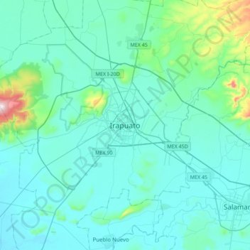
名称:Irapuato地形图、海拔、地势。
地点:Irapuato, Guanajuato, 36500, Mexico (20.51588 -101.51211 20.83588 -101.19211)
平均海拔:1,763 米
最低海拔:1,691 米
最高海拔:2,345 米