
Harding地形图
点击地图以显示海拔。
关于这张地图
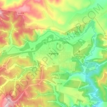
名称:Harding地形图、海拔、地势。
平均海拔:878 米
最低海拔:726 米
最高海拔:1,072 米
其他地形图
点击地图以查看其地形、其海拔和其地势。
Weza Forest
South Africa > KwaZulu-Natal > Ugu District Municipality > uMuziwabantu Local Municipality
Areas of forest which grow in KwaZulu-Natal, South Africa mostly on south facing slopes in higher rainfall areas, and along the humid coastal areas. Different types of forest can be identified by their species composition which depends mostly on the altitude, latitude and substrate (soil and rock types) in…
平均海拔:1,317 米