Doe Hill地形图
点击地图以显示海拔。
关于这张地图
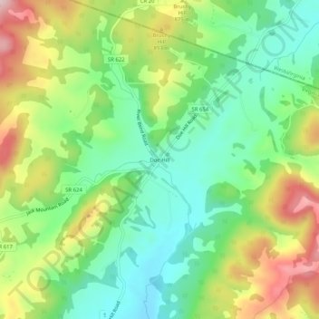
名称:Doe Hill地形图、海拔、地势。
地点:Doe Hill, Highland County, Virginia, 24443, United States (38.41207 -79.46449 38.45207 -79.42449)
平均海拔:830 米
最低海拔:725 米
最高海拔:999 米
其他地形图
点击地图以查看其地形、其海拔和其地势。

点击地图以显示海拔。
名称:Doe Hill地形图、海拔、地势。
地点:Doe Hill, Highland County, Virginia, 24443, United States (38.41207 -79.46449 38.45207 -79.42449)
平均海拔:830 米
最低海拔:725 米
最高海拔:999 米
点击地图以查看其地形、其海拔和其地势。