
Douglas Pass地形图
点击地图以显示海拔。
Douglas Pass
Douglas Pass, elevation 8,205 feet (2,501 meters), is a mountain pass in the Book Cliffs of western Colorado. It is located in Garfield County and is traversed by State Highway 139. The pass divides the watersheds of West Douglas Creek to the north and East Salt Creek to the south. It is named for the Northern Ute, Chief Douglas.
关于这张地图
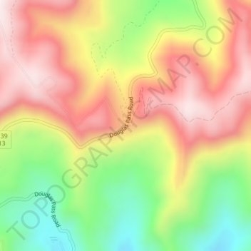
名称:Douglas Pass地形图、海拔、地势。
地点:Douglas Pass, Garfield County, Colorado, United States (39.59766 -108.80499 39.59776 -108.80489)
平均海拔:2,435 米
最低海拔:2,137 米
最高海拔:2,694 米
其他地形图
点击地图以查看其地形、其海拔和其地势。