
Cordes地形图
点击地图以显示海拔。
关于这张地图
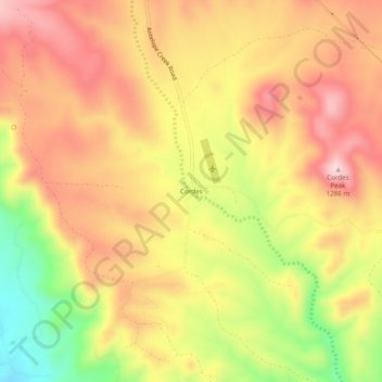
名称:Cordes地形图、海拔、地势。
地点:Cordes, Yavapai County, Arizona, 86333, United States (34.28336 -112.18683 34.32336 -112.14683)
平均海拔:1,170 米
最低海拔:1,002 米
最高海拔:1,287 米
其他地形图
点击地图以查看其地形、其海拔和其地势。
Prescott
United States > Arizona > Yavapai County
Prescott is in the Bradshaw Mountains of central Arizona, at an elevation of 5,400 feet (1,600 m). The city has a Mediterranean climate (Köppen Csa); however, unlike most other locations in this climate class, there is a pronounced summer wet season due to the North American Monsoon.
平均海拔:1,674 米
Prescott
United States > Arizona > Yavapai County
Prescott is in the Bradshaw Mountains of central Arizona, at an elevation of 5,400 feet (1,600 m). The city has a Mediterranean climate (Köppen Csa). However, unlike most other locations in this climate class, there is a pronounced summer wet season due to the North American Monsoon.
平均海拔:1,674 米
Prescott
United States > Arizona > Yavapai County
Prescott is in the Bradshaw Mountains of central Arizona, at an elevation of 5,400 feet (1,600 m). The city has a Mediterranean climate (Köppen Csa) bordering on a Humid subtropical climate (Köppen Cwa); however, unlike most other locations in this climate class, there is a pronounced summer wet season due…
平均海拔:1,674 米
Seligman
United States > Arizona > Yavapai County
Seligman is located at 35°19′42″N 112°52′27″W / 35.32833°N 112.87417°W / 35.32833; -112.87417 (35.328199, −112.874303), at 5,240 feet (1,600 m) in elevation, alongside the Big Chino Wash, in a northern section of Chino Valley. The wash is a major tributary of the Verde River. Seligman is…
平均海拔:1,617 米
Lynx Lake
United States > Arizona > Yavapai County
Lynx Lake, Arizona, is a 55-acre (220,000 m2) reservoir located within Prescott National Forest, approximately 5 miles (8.0 km) east of Prescott, Arizona, in the Bradshaw Mountains. The lake is located at 5,530 feet (1,690 m) elevation and is stocked for fishing. It is one of the most popular recreation areas…
平均海拔:1,726 米
Village of Oak Creek
United States > Arizona > Yavapai County
Big Park, Arizona (ZIP 86351), has a semi-arid climate (Köppen BSk) characterized by hot summers, mild winters, low humidity, and distinct wet and dry seasons. Its climate is shaped by its 4,000 ft (1,220 m) elevation, proximity to the Mogollon Rim, and surrounding red rock formations. Summers are hot but…
平均海拔:1,333 米
Chino Valley
United States > Arizona > Yavapai County
The town is in north-central Arizona, on state Highway 89, 15 miles (24 km) north of Prescott and 35 miles (56 km) south of Ash Fork, which is on Interstate 40. Chino Valley is at an elevation of about 4,750 feet (1,450 m).
平均海拔:1,454 米
Chino Valley
United States > Arizona > Yavapai County
The town is in north-central Arizona, on state Highway 89, 15 miles (24 km) north of Prescott and 35 miles (56 km) south of Ash Fork, which is on Interstate 40. Chino Valley is at an elevation of about 4,750 feet (1,450 m).
平均海拔:1,454 米
Seligman
United States > Arizona > Yavapai County
Seligman is located at 35°19′42″N 112°52′27″W / 35.32833°N 112.87417°W / 35.32833; -112.87417 (35.328199, −112.874303), at 5,240 feet (1,600 m) in elevation, alongside the Big Chino Wash, in a northern section of Chino Valley. The wash is a major tributary of the Verde River. Seligman is…
平均海拔:1,617 米
Jerome
United States > Arizona > Yavapai County
Jerome is about 100 miles (160 km) north of Phoenix and 45 miles (72 km) southwest of Flagstaff along Arizona State Route 89A between Sedona to the east and Prescott to the west. The town is in Arizona's Black Hills, which trend north–south. The town lies within the Prescott National Forest at an elevation…
平均海拔:1,574 米
Prescott Valley
United States > Arizona > Yavapai County
Prescott Valley (locally, PV) is located in central Arizona approximately 85 miles (137 km) north of Phoenix at 5,100 feet (1,600 m). elevation. PV has good access to Arizona State Route 89, SR-89A and SR-69, connecting to Interstates 17 and 40. Air service is available at Ernest A. Love Field, approximately 8…
平均海拔:1,550 米