
Walland地形图
点击地图以显示海拔。
关于这张地图
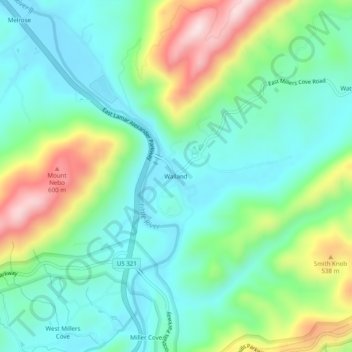
名称:Walland地形图、海拔、地势。
平均海拔:386 米
最低海拔:271 米
最高海拔:658 米
其他地形图
点击地图以查看其地形、其海拔和其地势。
Townsend
United States > Tennessee > Blount County
Just to the north and west of Townsend, the Foothills Parkway is a national parkway that traverses Chilhowee Mountain and offers multiple scenic overlooks at high elevations, with views of the Smokies to the south and the Tennessee Valley and Cumberland Plateau to the north and west. As of 2016, road…
平均海拔:376 米
Friendsville
United States > Tennessee > Blount County
Friendsville is located in western Blount County. The town is situated along State Route 333 (Miser Station Road) and stretches from Fort Loudoun Lake in the north to U.S. Route 321 (Lamar Alexander Parkway). It lies at an elevation of 879 feet (268 m).
平均海拔:280 米