
Veseli地形图
点击地图以显示海拔。
关于这张地图
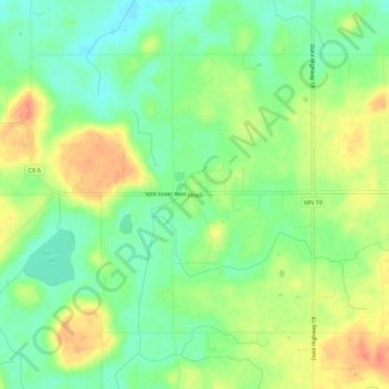
名称:Veseli地形图、海拔、地势。
平均海拔:327 米
最低海拔:304 米
最高海拔:357 米
其他地形图
点击地图以查看其地形、其海拔和其地势。
Northfield
United States > Minnesota > Rice County
According to the United States Census Bureau, the city has an area of 8.61 square miles (22.30 km2); 8.56 square miles (22.17 km2) is land and 0.05 square miles (0.13 km2) is water. The peak elevation is about 912 ft (278 m).
平均海拔:298 米
Northfield
United States > Minnesota > Rice County
According to the United States Census Bureau, the city has an area of 8.61 square miles (22.30 km2); 8.56 square miles (22.17 km2) is land and 0.05 square miles (0.13 km2) is water. The peak elevation is about 912 feet.
平均海拔:298 米
Northfield
United States > Minnesota > Rice County
According to the United States Census Bureau, the city has an area of 8.61 square miles (22.30 km2); 8.56 square miles (22.17 km2) is land and 0.05 square miles (0.13 km2) is water. The peak elevation is about 912 ft (278 m).
平均海拔:298 米
Dundas
United States > Minnesota > Rice County
According to the United States Census Bureau, the city has a total area of 1.92 square miles (4.97 km2), all land. The Cannon River passes through the center of town. The latitude of Dundas is 44.429N. The longitude is 93.204W. Dundas' elevation is 932 feet above sea level.
平均海拔:298 米