
Fair Oaks地形图
点击地图以显示海拔。
关于这张地图
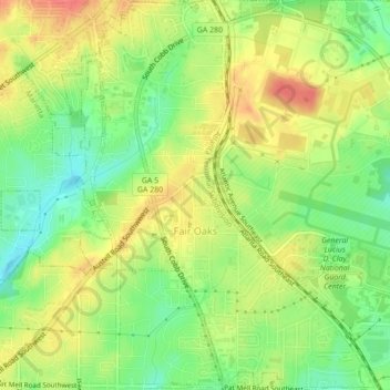
名称:Fair Oaks地形图、海拔、地势。
地点:Fair Oaks, Cobb County, Georgia, United States (33.90182 -84.55752 33.93780 -84.52548)
平均海拔:329 米
最低海拔:299 米
最高海拔:359 米
其他地形图
点击地图以查看其地形、其海拔和其地势。
Kennesaw Mountain
United States > Georgia > Cobb County
Kennesaw Mountain is a mountain between Marietta and Kennesaw, Georgia in the United States with a summit elevation of 1,808 feet (551 m). It is the highest point in the core (urban and suburban) metro Atlanta area, and fifth after further-north exurban counties are considered. The local terrain averages…
平均海拔:360 米
Kennesaw
United States > Georgia > Cobb County > Kennesaw
Kennesaw is located in northwestern Cobb County, bordered by the city of Acworth to the northwest. Kennesaw Mountain is located southeast of the city limits in the battlefield park. Its summit is the highest point in the Atlanta metro area, at an elevation of 1,808 feet (551 m) above sea level. The city was…
平均海拔:318 米