
Clock Spring地形图
点击地图以显示海拔。
关于这张地图
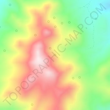
名称:Clock Spring地形图、海拔、地势。
平均海拔:2,522 米
最低海拔:2,277 米
最高海拔:2,772 米
其他地形图
点击地图以查看其地形、其海拔和其地势。
Ely
United States > Nevada > White Pine County
Ely experiences a semi-arid climate (Köppen BSk), and extreme day-night temperature differences year-round. Ely's nighttime temperatures account for it being listed as one of the coldest places in the contiguous United States, with an average of 214.9 nights per year with a minimum temperature of 32 °F (0…
平均海拔:2,045 米
Great Basin National Park
United States > Nevada > White Pine County
The park derives its name from the Great Basin, the dry and mountainous region between the Sierra Nevada and the Wasatch Mountains. Topographically, this area is known as the Basin and Range Province. The park is located about 290 miles (470 km) north of Las Vegas and protects 77,180 acres (31,230 ha).
平均海拔:2,352 米