
Cape Cod地形图
点击地图以显示海拔。
Cape Cod
Cape Cod extends 65 miles (105 km) into the Atlantic Ocean, with a breadth of between 1–20 miles (1.6–32.2 km), and covers more than 400 miles (640 km) of shoreline. Its elevation ranges from 306 feet (93 m) at its highest point, at the top of Pine Hill, in the Bourne portion of Joint Base Cape Cod, down to sea level.
关于这张地图
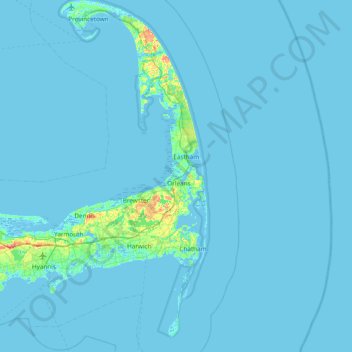
名称:Cape Cod地形图、海拔、地势。
地点:Cape Cod, Barnstable County, Massachusetts, United States (41.51497 -70.68798 42.08253 -69.92900)
平均海拔:2 米
最低海拔:-6 米
最高海拔:56 米
其他地形图
点击地图以查看其地形、其海拔和其地势。