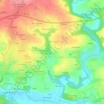
点击地图以显示海拔。
名称:Kercadic地形图、海拔、地势。
地点:Kercadic, Baud, Pontivy, Morbihan, Bretagne, France métropolitaine, 56150, France (47.86099 -3.01240 47.90099 -2.97240)
平均海拔:76 米
最低海拔:27 米
最高海拔:135 米
点击地图以查看其地形、其海拔和其地势。
France > Bretagne > Morbihan > Baud
平均海拔:71 米
France > Bretagne > Morbihan > Baud > Kernantec
平均海拔:83 米