Black Snake地形图
点击地图以显示海拔。
关于这张地图
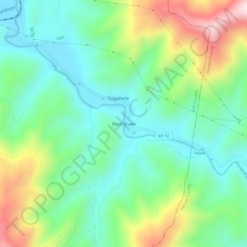
名称:Black Snake地形图、海拔、地势。
地点:Black Snake, Bell County, Kentucky, 40845, United States (36.74814 -83.52325 36.78814 -83.48325)
平均海拔:508 米
最低海拔:322 米
最高海拔:912 米
其他地形图
点击地图以查看其地形、其海拔和其地势。

点击地图以显示海拔。
名称:Black Snake地形图、海拔、地势。
地点:Black Snake, Bell County, Kentucky, 40845, United States (36.74814 -83.52325 36.78814 -83.48325)
平均海拔:508 米
最低海拔:322 米
最高海拔:912 米
点击地图以查看其地形、其海拔和其地势。