
Lewes地形图
点击地图以显示海拔。
关于这张地图
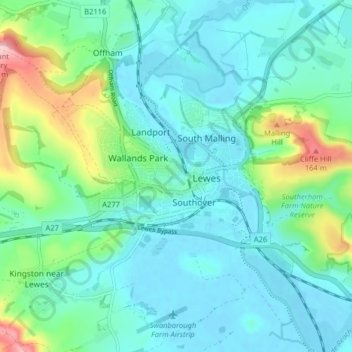
名称:Lewes地形图、海拔、地势。
地点:Lewes, East Sussex, England, United Kingdom (50.85948 -0.03090 50.88925 0.04931)
平均海拔:36 米
最低海拔:-2 米
最高海拔:164 米
其他地形图
点击地图以查看其地形、其海拔和其地势。
Speckled Wood, Hastings
United Kingdom > England > East Sussex > Hastings
The Upper Ore Valley to date has steep sixty-degree valleys or inclines to the north, east and west. The stream cuts right through the lower valley exposing the Ashdown bed in sections along the valley floor. To the west the incline falls off to a plateau which then rises to land level. The North End of the…
平均海拔:92 米