
Adalaj地形图
点击地图以显示海拔。
Adalaj
Adalaj is located at 23°10′N 72°35′E / 23.17°N 72.58°E / 23.17; 72.58. It has an average elevation of 66 metres (217 ft). According to the Bureau of Indian Standards, the town falls under seismic zone 3, in a scale of 2 to 5 (in order of increasing vulnerability to earthquakes).
关于这张地图
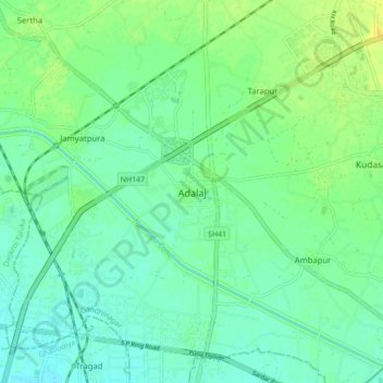
名称:Adalaj地形图、海拔、地势。
平均海拔:66 米
最低海拔:58 米
最高海拔:79 米
其他地形图
点击地图以查看其地形、其海拔和其地势。
Gandhinagar
India > Gujarat > Gandhinagar Taluka
Gandhinagar has an average elevation of 81 metres (266 feet). The city sits on the banks of the Sabarmati River, in north-central-east Gujarat. The 20,543 km2 area around Gandhinagar is defined by Gujarat capital territory. Gandhinagar spans an area of 326 km2 (126 sq mi). The river frequently dries up in the…
平均海拔:75 米