点击地图以显示海拔。
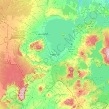
名称:Rotorua地形图、海拔、地势。
地点:Rotorua, Rotorua Lakes District, Bay of Plenty, 3010, New Zealand (-38.29815 176.09292 -37.97815 176.41292)
平均海拔:435 米
最低海拔:215 米
最高海拔:860 米
点击地图以查看其地形、其海拔和其地势。
New Zealand > Bay of Plenty > Rotorua Lakes District
平均海拔:339 米
New Zealand > Bay of Plenty > Rotorua Lakes District > Lake Okareka
平均海拔:392 米
New Zealand > Bay of Plenty > Rotorua Lakes District > Hamurana
平均海拔:299 米