
Apple Grove地形图
点击地图以显示海拔。
关于这张地图
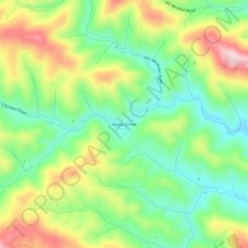
名称:Apple Grove地形图、海拔、地势。
地点:Apple Grove, Ashe County, North Carolina, United States (36.50873 -81.60483 36.54873 -81.56483)
平均海拔:1,001 米
最低海拔:867 米
最高海拔:1,202 米
其他地形图
点击地图以查看其地形、其海拔和其地势。
West Jefferson
United States > North Carolina > Ashe County
West Jefferson is a popular destination among tourists and retirees from Florida, as well as those from the lower elevations of the Carolinas and Georgia.
平均海拔:1,002 米
Jefferson
United States > North Carolina > Ashe County
Due to its high elevation, Jefferson has an oceanic or subtropical highland climate, (Köppen Cfb), with the coldst month of January averaging slightly above freezing, while summers are much milder than most of the southeast, with July averaging below 70 degrees fahrenheit.
平均海拔:979 米
Lansing
United States > North Carolina > Ashe County
Lansing is a popular destination among retirees and tourists from Florida, as well as those from the lower elevations of the Carolinas and Georgia.
平均海拔:879 米
Lansing
United States > North Carolina > Ashe County
Lansing is a popular destination among retirees and tourists from Florida, as well as those from the lower elevations of the Carolinas and Georgia.
平均海拔:879 米
West Jefferson
United States > North Carolina > Ashe County
West Jefferson is a popular destination among tourists and retirees from Florida, as well as those from the lower elevations of the Carolinas and Georgia.
平均海拔:1,002 米