
Vigna地形图
点击地图以显示海拔。
关于这张地图
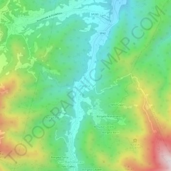
名称:Vigna地形图、海拔、地势。
地点:Vigna, Chiusa di Pesio, Cuneo, Piedmont, 12013, Italy (44.26207 7.64784 44.30207 7.68784)
平均海拔:912 米
最低海拔:630 米
最高海拔:1,495 米
其他地形图
点击地图以查看其地形、其海拔和其地势。
Chiusa di Pesio
Chiusa di Pesio is located at the beginning of the Pesio Valley (its altitude ranges from 575 metres of the main town up to over 2,600 metres of the highest peaks). The main hamlets are San Bartolomeo and Vigna, located in the highest part of the valley, and Combe, Santa Maria Rocca and Abrau which are located…
平均海拔:1,147 米
Peveragno
The town has an average altitude above sea level of 570 meters. At the foot of Mount Bisalta, whose name derives from the fact that it consists of two peaks close to each other but well distinguished, the highest one is 2404 m above sea level. With its main villages, S. Margherita, S. Lorenzo, S. Giovenale,…
平均海拔:860 米