
Mount Bachelor地形图
点击地图以显示海拔。
Mount Bachelor
Mount Bachelor lies in the Cascade Range, within Deschutes County, in the U.S. state of Oregon. It is located south of the Three Sisters complex volcano, and reaches an elevation of 9,068 feet (2,764 m). It rises 3,500 feet (1,100 m) above its base, with a proximal relief of 2,674 feet (815 m). The volcano has a volume of 6.0 cubic miles (25 km3). Mount Bachelor stands 3 miles (4.8 km) southeast of the Tumalo Mountain volcano and 18 miles (29 km) to the southwest of the city of Bend, in the Deschutes National Forest.
关于这张地图
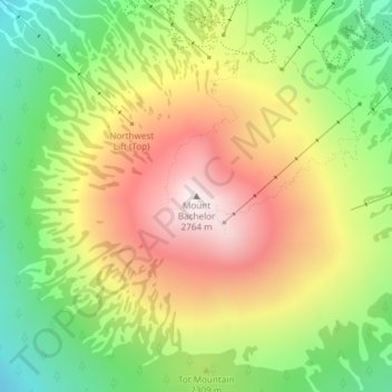
名称:Mount Bachelor地形图、海拔、地势。
地点:Mount Bachelor, Deschutes County, Oregon, United States (43.97933 -121.68856 43.97943 -121.68846)
平均海拔:2,325 米
最低海拔:1,928 米
最高海拔:2,756 米
其他地形图
点击地图以查看其地形、其海拔和其地势。
Bend
United States > Oregon > Deschutes County
Bend is characterized by its distinctive topography, situated at an elevation of approximately 3,623 feet (1,105 meters) above sea level. The city lies within the high desert region of Central Oregon, bordered by the Cascade Mountains to the west, which provide a dramatic backdrop with peaks like the Three…
平均海拔:1,121 米
Redmond
United States > Oregon > Deschutes County
The city encompasses 15.5 square miles (40 km2) and is on a plateau, at an elevation of 3,077 feet (938 m). Redmond is 15 miles (24 km) north of Bend—the county seat of Deschutes County—144 miles (232 km) from Portland, 129 miles (208 km) from Salem—the capital of Oregon—and 126 miles (203 km) from Eugene.
平均海拔:923 米
Bend
United States > Oregon > Deschutes County
The Deschutes River runs through Bend, where it is dammed to form Mirror Pond. Bend's elevation is 3,623 feet (1,104 metres) above sea level. The city has a total area of 33.27 square miles (86.17 square kilometres), of which 33.01 sq mi (85.50 km2) is land and 0.26 sq mi (0.67 km2) is water.
平均海拔:1,121 米
Bend
United States > Oregon > Deschutes County
The Deschutes River runs through Bend, where it is dammed to form Mirror Pond. Bend's elevation is 3,623 feet (1,104 metres) above sea level.
平均海拔:1,121 米
Bend
United States > Oregon > Deschutes County
The Deschutes River runs through Bend, where it is dammed to form Mirror Pond. Bend's elevation is 3,623 feet (1,104 metres) above sea level.
平均海拔:1,121 米
Bend
United States > Oregon > Deschutes County
The Deschutes River runs through Bend, where it is dammed to form Mirror Pond. Bend's elevation is 3,623 feet (1,104 metres) above sea level.
平均海拔:1,121 米
Redmond
United States > Oregon > Deschutes County > Redmond
The city encompasses 15.5 square miles (40 km2) and is on a plateau, at an elevation of 3,077 feet (938 m). Redmond is 15 miles (24 km) north of Bend—the county seat of Deschutes County—144 miles (232 km) from Portland, 129 miles (208 km) from Salem—the capital of Oregon—and 126 miles (203 km) from Eugene.
平均海拔:921 米