
Marabilis地形图
点击地图以显示海拔。
关于这张地图
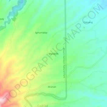
名称:Marabilis地形图、海拔、地势。
平均海拔:668 米
最低海拔:548 米
最高海拔:925 米
其他地形图
点击地图以查看其地形、其海拔和其地势。
Mount Kanlaon Natural Park
Philippines > Negros Occidental > San Carlos
Kanlaon, also known as Mount Kanlaon and Kanlaon Volcano (Hiligaynon: Bolkang Kanglaon; Cebuano: Bolkang Kanglaon; Filipino: Bulkang Kanlaon), is an active stratovolcano and the highest mountain on the island of Negros in the Philippines, as well as the highest point in the Visayas, with an elevation of 2,465…
平均海拔:650 米