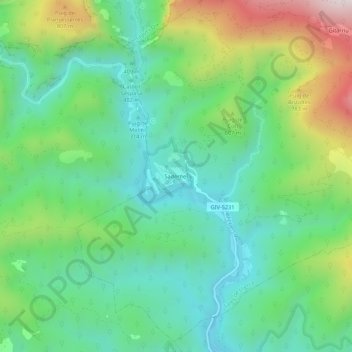
点击地图以显示海拔。
名称:Sadernes地形图、海拔、地势。
地点:Sadernes, Sales de Llierca, Garrotxa, Gérone, Catalogne, 17855, Espagne (42.25051 2.57559 42.29051 2.61559)
平均海拔:487 米
最低海拔:224 米
最高海拔:1,075 米
点击地图以查看其地形、其海拔和其地势。
Espagne > Catalogne > Garrotxa
平均海拔:560 米
平均海拔:477 米
平均海拔:499 米
平均海拔:398 米
平均海拔:722 米
平均海拔:601 米
平均海拔:389 米
平均海拔:484 米