Castle Danger地形图
点击地图以显示海拔。
关于这张地图
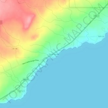
名称:Castle Danger地形图、海拔、地势。
地点:Castle Danger, Lake County, Minnesota, United States (47.10076 -91.52323 47.14076 -91.48323)
平均海拔:212 米
最低海拔:179 米
最高海拔:289 米
其他地形图
点击地图以查看其地形、其海拔和其地势。

点击地图以显示海拔。
名称:Castle Danger地形图、海拔、地势。
地点:Castle Danger, Lake County, Minnesota, United States (47.10076 -91.52323 47.14076 -91.48323)
平均海拔:212 米
最低海拔:179 米
最高海拔:289 米
点击地图以查看其地形、其海拔和其地势。