
Bredasdorp地形图
点击地图以显示海拔。
Bredasdorp
Bredasdorp is situated at an elevation of between 40 and 120 metres (130 and 390 ft) on the slopes of the Heuningberg (Afrikaans for "Honey Mountain"). There is no significant watercourse flowing through the town, although the Kars Rivier flows past a few kilometres to the east.
关于这张地图
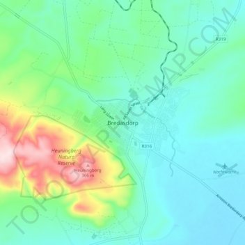
名称:Bredasdorp地形图、海拔、地势。
平均海拔:104 米
最低海拔:17 米
最高海拔:384 米
其他地形图
点击地图以查看其地形、其海拔和其地势。