点击地图以显示海拔。
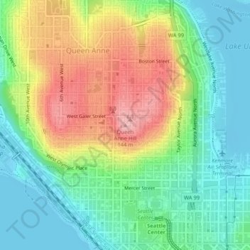
名称:Queen Anne Hill地形图、海拔、地势。
地点:Queen Anne Hill, Seattle, King County, Washington, 98109, United States (47.63129 -122.35480 47.63139 -122.35470)
平均海拔:55 米
最低海拔:-8 米
最高海拔:145 米
点击地图以查看其地形、其海拔和其地势。
United States > Washington > King County > Seattle
平均海拔:71 米
平均海拔:52 米
平均海拔:42 米
平均海拔:51 米
平均海拔:54 米
平均海拔:17 米
平均海拔:28 米
平均海拔:32 米
平均海拔:37 米
平均海拔:38 米
平均海拔:73 米
平均海拔:62 米
平均海拔:4 米
平均海拔:41 米
平均海拔:39 米
平均海拔:53 米
平均海拔:22 米
平均海拔:59 米