
Superior地形图
点击地图以显示海拔。
关于这张地图
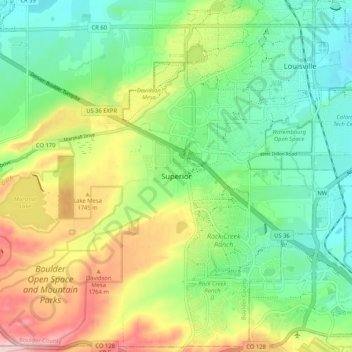
名称:Superior地形图、海拔、地势。
地点:Superior, Boulder County, Colorado, 80027, United States (39.91276 -105.20860 39.99276 -105.12860)
平均海拔:1,689 米
最低海拔:1,607 米
最高海拔:1,832 米
其他地形图
点击地图以查看其地形、其海拔和其地势。
Boulder
United States > Colorado > Boulder County
Boulder is located at the base of the foothills of the Rocky Mountains, at an elevation of 5,430 feet (1,655 m) above sea level. Boulder is 25 miles (40 km) northwest of the Colorado state capital of Denver. It is home of the main campus of the University of Colorado, the state's largest university.
平均海拔:1,800 米
Longmont
United States > Colorado > Boulder County
The elevation at City Hall is 4,978 feet (1,517 m) above sea level. St. Vrain Creek, a tributary of the South Platte River, flows through the city just south of the city center.
平均海拔:1,534 米
Longmont
United States > Colorado > Boulder County
The elevation at City Hall is 4,978 feet (1,517 m) above sea level. St. Vrain Creek, a tributary of the South Platte River, flows through the city just south of the city center.
平均海拔:1,537 米
Ward
United States > Colorado > Boulder County
Ward is a home rule municipality in Boulder County, Colorado, United States. The population was 128 at the 2020 census. The town is a former mining settlement founded in 1860 in the wake of the discovery of gold at nearby Gold Hill. Once one of the richest towns in the state during the Colorado Gold Rush, it…
平均海拔:2,826 米
Boulder
United States > Colorado > Boulder County
Boulder is located at the base of the foothills of the Rocky Mountains, at an elevation of 5,430 feet (1,655 m) above sea level. The city is 25 miles (40 km) northwest of the Colorado state capital of Denver. Boulder is a college town, hosting the University of Colorado Boulder, the flagship and largest campus…
平均海拔:1,800 米
Ward
United States > Colorado > Boulder County
Ward is a home rule municipality in Boulder County, Colorado, United States. The population was 128 at the 2020 census. The town is a former mining settlement founded in 1860 in the wake of the discovery of gold at nearby Gold Hill. Once one of the richest towns in the state during the Colorado Gold Rush, it…
平均海拔:2,826 米
Boulder
United States > Colorado > Boulder County
Boulder is located at the base of the foothills of the Rocky Mountains, at an elevation of 5,430 feet (1,655 m) above sea level. The city is 25 miles (40 km) northwest of the Colorado state capital of Denver. Boulder is a college town, hosting the University of Colorado Boulder, the flagship and largest campus…
平均海拔:1,800 米
Nederland
United States > Colorado > Boulder County
In 1873 the Caribou Mine, at an elevation of roughly 10,000 feet (3,000 m) and 6 miles (10 km) northwest of the town, was sold to the Mining Company Nederland from the Netherlands. The high elevation meant fierce winds and deep winter snow, so the new owners of the mine decided that it was beneficial to bring…
平均海拔:2,578 米
Allenspark
United States > Colorado > Boulder County
Allenspark is located in northwest Boulder County within Roosevelt National Forest in the Front Range of the Colorado Rockies. The western edge of the community is the boundary of Rocky Mountain National Park. State Highway 7 passes through the community, leading north 15 miles (24 km) to Estes Park and east…
平均海拔:2,874 米
Allenspark
United States > Colorado > Boulder County > Allenspark
Allenspark is located in northwest Boulder County within Roosevelt National Forest in the Front Range of the Colorado Rockies. The western edge of the community is the boundary of Rocky Mountain National Park. State Highway 7 passes through the community, leading north 15 miles (24 km) to Estes Park and east…
平均海拔:2,874 米
Boulder
United States > Colorado > Boulder County
Boulder is located at the base of the foothills of the Rocky Mountains, at an elevation of 5,430 feet (1,655 m) above sea level. The city is 25 miles (40 km) northwest of the Colorado state capital of Denver. Boulder is a college town, hosting the largest campus of the University of Colorado (the state's…
平均海拔:1,800 米
Longmont
United States > Colorado > Boulder County
The elevation at City Hall is 4,978 feet (1,517 m) above sea level. St. Vrain Creek, a tributary of the South Platte River, flows through the city just south of the city center.
平均海拔:1,534 米
Nederland
United States > Colorado > Boulder County
In 1873 the Caribou Mine, at an elevation of roughly 10,000 feet (3,000 m) and 6 miles (10 km) northwest of the town, was sold to the Mining Company Nederland from the Netherlands. The high elevation meant fierce winds and deep winter snow, so the new owners of the mine decided that it was beneficial to bring…
平均海拔:2,578 米
National Center for Atmospheric Research
United States > Colorado > Boulder County > Boulder
平均海拔:1,816 米