Catherine Lake地形图
点击地图以显示海拔。
关于这张地图
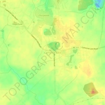
名称:Catherine Lake地形图、海拔、地势。
地点:Catherine Lake, Onslow County, North Carolina, United States (34.79766 -77.58386 34.83766 -77.54386)
平均海拔:24 米
最低海拔:-8 米
最高海拔:40 米
其他地形图
点击地图以查看其地形、其海拔和其地势。

点击地图以显示海拔。
名称:Catherine Lake地形图、海拔、地势。
地点:Catherine Lake, Onslow County, North Carolina, United States (34.79766 -77.58386 34.83766 -77.54386)
平均海拔:24 米
最低海拔:-8 米
最高海拔:40 米
点击地图以查看其地形、其海拔和其地势。