
Greenbank地形图
点击地图以显示海拔。
关于这张地图
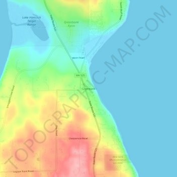
名称:Greenbank地形图、海拔、地势。
地点:Greenbank, Island County, Washington, 98253, United States (48.07857 -122.59215 48.11857 -122.55215)
平均海拔:39 米
最低海拔:-2 米
最高海拔:136 米
其他地形图
点击地图以查看其地形、其海拔和其地势。
Whidbey Island
United States > Washington > Island County
Whidbey Island features a diverse topography characterized by a mix of rolling hills, lush forests, and dramatic coastal cliffs. The island stretches approximately 55 miles in length and up to 12 miles wide, rising to elevations of about 500 feet at its highest point. Its terrain includes expansive farmland…
平均海拔:45 米
Whidbey Island
United States > Washington > Island County
Whidbey Island lies partially in the rain shadow of the Olympic Mountain Range to the west, and has a variety of climate zones. This can be observed by rainfall amounts – wettest in the south with average rainfall of 36 inches (910 mm), driest in the central district of Coupeville with average rainfall of 20…
平均海拔:45 米