
Chief Mountain地形图
点击地图以显示海拔。
关于这张地图
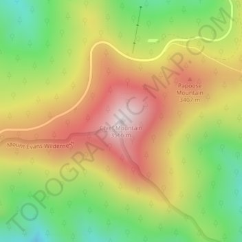
名称:Chief Mountain地形图、海拔、地势。
平均海拔:3,225 米
最低海拔:2,897 米
最高海拔:3,554 米
其他地形图
点击地图以查看其地形、其海拔和其地势。
Georgetown
United States > Colorado > Clear Creek County
The town sits at an elevation of 8,530 feet (2,600 m) above sea level, nestled in the mountains near the upper end of the valley of Clear Creek in the mountains west of Denver along Interstate 70. Although population was only about 1,000 at the 2010 census, the town was a historic center of the mining industry…
平均海拔:2,974 米