
Briggs地形图
点击地图以显示海拔。
Briggs
Briggs lies along U.S. Route 183 and FM 2657, northeast of Burnet. Its elevation is 1,102 feet (336 m), and it is located at 30°53′23″N 97°55′30″W / 30.88972°N 97.92500°W / 30.88972; -97.92500. Although Briggs is unincorporated, it has a post office, with the ZIP code of 78608. The population was 101 at the 2020 census.
关于这张地图
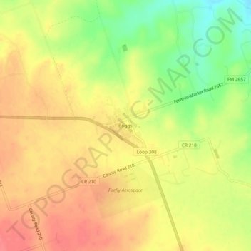
名称:Briggs地形图、海拔、地势。
地点:Briggs, Burnet County, Texas, 78608, United States (30.86877 -97.94581 30.90877 -97.90581)
平均海拔:336 米
最低海拔:295 米
最高海拔:362 米
其他地形图
点击地图以查看其地形、其海拔和其地势。
Inks Lake State Park
United States > Texas > Burnet County > Burnet
Conservation Pool Elevation usually stays around 888.22 ft. msl; however, this lake does fluctuate about 1 foot annually. Inks lake water clarity can be seen as clear to slightly stained mostly throughout the year. It tends to have higher turbidity during the rainy season due to excessive amounts of runoff.
平均海拔:294 米