
Sierra Nevada地形图
点击地图以显示海拔。
关于这张地图
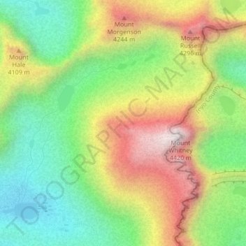
名称:Sierra Nevada地形图、海拔、地势。
地点:Sierra Nevada, Tulare County, California, United States (36.57995 -118.30005 36.58005 -118.29995)
平均海拔:3,888 米
最低海拔:3,492 米
最高海拔:4,415 米
其他地形图
点击地图以查看其地形、其海拔和其地势。
Sequoia National Park
United States > California > Tulare County
Many park visitors enter Sequoia National Park through its southern entrance near the town of Three Rivers at Ash Mountain at 1,700 ft (520 m) elevation. The lower elevations around Ash Mountain contain the only National Park Service-protected California Foothills ecosystem, consisting of blue oak woodlands,…
平均海拔:2,515 米
Porterville
United States > California > Tulare County
Porterville, lying along the foothills of the Sierras at an elevation of 455 feet (139 m), is located on State Highway 65, 165 miles (266 km) north of Los Angeles, and 171 miles (275 km) east of the Pacific Coast. The city has a strategic central location to major markets and a ready access to major…
平均海拔:175 米
Sequoia National Park
United States > California > Tulare County
Many park visitors enter Sequoia National Park through its southern entrance near the town of Three Rivers at Ash Mountain at 1,700 ft (520 m) elevation. The lower elevations around Ash Mountain contain the only National Park Service-protected California Foothills ecosystem, consisting of blue oak woodlands,…
平均海拔:2,515 米
Kennedy Meadows
United States > California > Tulare County
The Kennedy Meadows area is at approximately 6200 feet elevation. The most common access route is by the steep Sherman Pass Road from U.S. Route 395 near Pearsonville. Other routes are possible but much slower.
平均海拔:1,992 米
Sequoia National Park
United States > California > Tulare County
Many park visitors enter Sequoia National Park through its southern entrance near the town of Three Rivers at Ash Mountain at 1,700 ft (520 m) elevation. The lower elevations around Ash Mountain contain the only National Park Service-protected California Foothills ecosystem, consisting of blue oak woodlands,…
平均海拔:2,515 米
Porterville
United States > California > Tulare County
Porterville, lying along the foothills of the Sierras at an elevation of 455 feet (139 m), is located on State Highway 65, 165 miles (266 km) north of Los Angeles, and 171 miles (275 km) east of the Pacific Coast. The city has a strategic central location to major markets and a ready access to major…
平均海拔:175 米
Dinuba
United States > California > Tulare County
According to the United States Census Bureau, the city has a total area of 6.5 square miles (17 km2), all of it land. The general topography is quite level ground, at an elevation of approximately 345 feet (105 m) above mean sea datum. The gradient is approximately ten feet per mile, from east-northeast to…
平均海拔:107 米
Porterville
United States > California > Tulare County
Porterville, lying along the foothills of the Sierras at an elevation of 455 feet (139 m), is located on State Highway 65, 165 miles (266 km) north of Los Angeles, and 171 miles (275 km) east of the Pacific Coast. The city has a strategic central location to major markets and a ready access to major…
平均海拔:175 米