Point of View地形图
点击地图以显示海拔。
关于这张地图
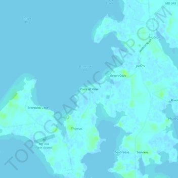
名称:Point of View地形图、海拔、地势。
地点:Point of View, Dorchester County, Maryland, United States (38.56040 -76.29328 38.60040 -76.25328)
平均海拔:1 米
最低海拔:-2 米
最高海拔:11 米
其他地形图
点击地图以查看其地形、其海拔和其地势。

点击地图以显示海拔。
名称:Point of View地形图、海拔、地势。
地点:Point of View, Dorchester County, Maryland, United States (38.56040 -76.29328 38.60040 -76.25328)
平均海拔:1 米
最低海拔:-2 米
最高海拔:11 米
点击地图以查看其地形、其海拔和其地势。