点击地图以显示海拔。
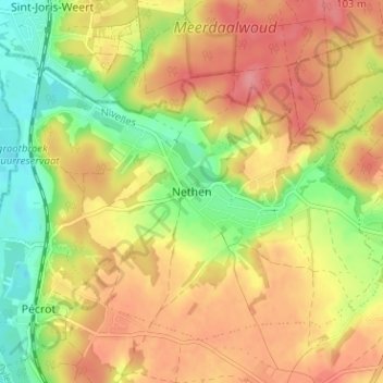
名称:Nethen地形图、海拔、地势。
地点:Nethen, Grez-Doiceau, Nivelles, Brabant wallon, Wallonie, 3051, Belgique (50.76382 4.65549 50.80382 4.69549)
平均海拔:68 米
最低海拔:21 米
最高海拔:106 米
点击地图以查看其地形、其海拔和其地势。
Belgique > Brabant wallon > Nivelles > Grez-Doiceau > Archennes
平均海拔:67 米
Belgique > Brabant wallon > Nivelles > Grez-Doiceau
平均海拔:66 米
平均海拔:59 米