
Cleveland地形图
点击地图以显示海拔。
Cleveland
The land rises quickly from the lake shore elevation of 569 feet. Public Square, less than one mile (1.6 km) inland, sits at an elevation of 650 feet (198 m), and Hopkins Airport, 5 miles (8 km) inland from the lake, is at an elevation of 791 feet (241 m).
关于这张地图
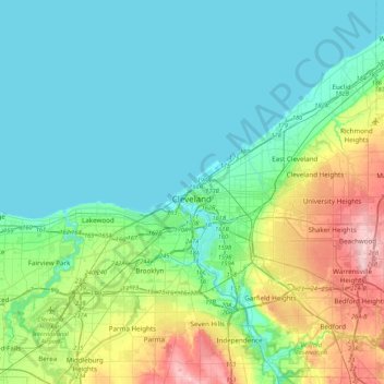
名称:Cleveland地形图、海拔、地势。
地点:Cleveland, Cuyahoga County, Ohio, 44113, United States (41.33966 -81.85368 41.65966 -81.53368)
平均海拔:221 米
最低海拔:171 米
最高海拔:385 米