
South Ockendon地形图
点击地图以显示海拔。
关于这张地图
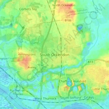
名称:South Ockendon地形图、海拔、地势。
平均海拔:14 米
最低海拔:-8 米
最高海拔:43 米
其他地形图
点击地图以查看其地形、其海拔和其地势。
Epping Forest
United Kingdom > England > Essex > Epping Forest
It lies on a ridge between the valleys of the rivers Lea and Roding. It contains areas of woodland, grassland, heath, streams, bogs, and ponds, and its elevation and thin gravelly soil (the result of glaciation) historically made it less suitable for agriculture. The forest was historically managed as a…
平均海拔:44 米
Canvey Island
United Kingdom > England > Essex > Castle Point > Canvey
In 1607 the Elizabethan antiquarian William Camden noted in his work Britannia (a topographical and historical survey of all of Great Britain and Ireland) that Canvey Island (which he called Island Convennon) was documented in the 2nd century by the Alexandrian geographer Ptolemy. In his work Geographia,…
平均海拔:10 米
Epping Forest
United Kingdom > England > Essex > Epping Forest > Debden Green
It lies on a ridge between the valleys of the rivers Lea and Roding. It contains areas of woodland, grassland, heath, streams, bogs and ponds, and its elevation and thin gravelly soil (the result of glaciation) historically made it less suitable for agriculture. The Forest was historically managed as a common;…
平均海拔:44 米