
Pleasant Valley地形图
点击地图以显示海拔。
关于这张地图
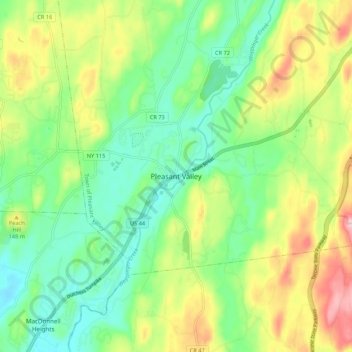
名称:Pleasant Valley地形图、海拔、地势。
平均海拔:109 米
最低海拔:44 米
最高海拔:219 米
其他地形图
点击地图以查看其地形、其海拔和其地势。
Hillside Lake
United States > New York > Dutchess County > Town of East Fishkill > Hillside Lake
平均海拔:103 米
Town of Pawling
United States > New York > Dutchess County
The eastern and western section of the towns are high and hilly, with the Great Swamp and Harlem Valley in the middle, where the village of Pawling is located. The highest elevation in town is Observatory Hill, at 1,332 feet (406 m) above sea level; the lowest is 420 feet (130 m), in the Great Swamp, along the…
平均海拔:243 米
City of Poughkeepsie
United States > New York > Dutchess County
According to the United States Census Bureau, the city has an area of 5.7 square miles (14.8 km2), of which 5.1 square miles (13.3 km2) is land, and 0.23 square miles (0.6 km2) (comprising 10.05%) is water. Poughkeepsie lies approximately 75 miles (121 km) north of the center of the New York megacity. It is…
平均海拔:49 米
Town of Fishkill
United States > New York > Dutchess County
According to the United States Census Bureau, the town has a total area of 32.0 square miles (82.9 km2), of which 27.3 square miles (70.8 km2) is land and 4.7 square miles (12.1 km2), or 14.55%, is water. The elevation of the town varies from sea level along the Hudson River (Fishkill Waterfront, Fishkill…
平均海拔:178 米
Town of Pawling
United States > New York > Dutchess County
The eastern and western section of the towns are high and hilly, with the Great Swamp and Harlem Valley in the middle, where the village of Pawling is located. The highest elevation in town is Observatory Hill, at 1,332 feet (406 m) above sea level; the lowest is 420 feet (130 m), in the Great Swamp, along the…
平均海拔:243 米
Rhinecliff
United States > New York > Dutchess County > Town of Rhinebeck
The hamlet is demarcated by large agricultural and wooded area to the north, east, and south, and bounded by the Hudson River on the west. Steep topography, formed by contorted slate ridges and valleys, define the site-specific and seemingly random orientation of the small, frame nineteenth-century houses and…
平均海拔:19 米
Town of North East
United States > New York > Dutchess County
Brace Mountain's 2,311-foot (704 m) summit, near the Connecticut state line in the northeastern corner of town, is the highest point in Dutchess County. The lowest elevation is 530 feet (160 m), along Shekomeko Creek at the Pine Plains town line.
平均海拔:267 米
Town of Fishkill
United States > New York > Dutchess County
According to the United States Census Bureau, the town has a total area of 32.0 square miles (82.9 km2), of which 27.3 square miles (70.8 km2) is land and 4.7 square miles (12.1 km2), or 14.55%, is water. The elevation of the town varies from sea level along the Hudson River (Fishkill Waterfront, Fishkill…
平均海拔:178 米