点击地图以显示海拔。
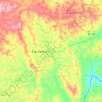
名称:San Vicente地形图、海拔、地势。
地点:San Vicente, Oriente, Antioquia, RAP del Agua y la Montaña, Colombia (6.24268 -75.37182 6.32268 -75.29182)
平均海拔:2,191 米
最低海拔:1,966 米
最高海拔:2,409 米
点击地图以查看其地形、其海拔和其地势。
Colombia > Antioquia > San Vicente
平均海拔:2,251 米
平均海拔:2,269 米
平均海拔:2,247 米
平均海拔:2,135 米