
Mount Selman地形图
点击地图以显示海拔。
关于这张地图
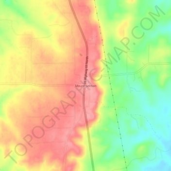
名称:Mount Selman地形图、海拔、地势。
地点:Mount Selman, Cherokee County, Texas, United States (32.04776 -95.30385 32.08776 -95.26385)
平均海拔:173 米
最低海拔:119 米
最高海拔:215 米
其他地形图
点击地图以查看其地形、其海拔和其地势。
Alto
United States > Texas > Cherokee County
The town of Alto was laid out in 1849 and named for the Spanish word meaning "high," on account of the site's elevation on a drainage divide between the Neches and Angelina Rivers.
平均海拔:130 米