
Rowena地形图
点击地图以显示海拔。
关于这张地图
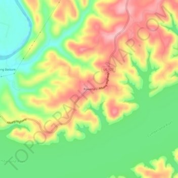
名称:Rowena地形图、海拔、地势。
地点:Rowena, Russell County, Kentucky, United States (36.85784 -85.12634 36.89784 -85.08634)
平均海拔:235 米
最低海拔:165 米
最高海拔:310 米
其他地形图
点击地图以查看其地形、其海拔和其地势。
Lake Cumberland
United States > Kentucky > Russell County > Burnside
Lake Cumberland is a reservoir in Clinton, Russell, Wayne, Pulaski and Laurel counties in Kentucky. The primary reasons for its construction were a means for flood control and the production of hydroelectric power. Its shoreline measures 1,255 miles (2,020 km) and the lake covers 65,530 acres (265 km2) at the…
平均海拔:289 米