
Jijiga地形图
点击地图以显示海拔。
Jijiga
Jijiga (Amharic: ጂጂጋ; Somali: Jigjiga) is a city in the Somali Region of Ethiopia. It became the capital of the Somali Regional State in 1995 after it was moved from Godey. Located in the Fafan Zone with 60 km (37 mi) west of the border with Somaliland, the city has an elevation of 1,934 metres above sea level.
关于这张地图
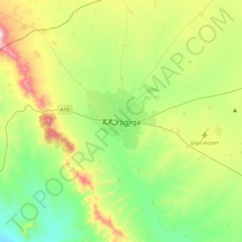
名称:Jijiga地形图、海拔、地势。
地点:Jijiga, Somali Region, Ethiopia (9.19085 42.64038 9.51085 42.96038)
平均海拔:1,732 米
最低海拔:1,393 米
最高海拔:2,474 米