
Peniel地形图
点击地图以显示海拔。
关于这张地图
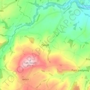
名称:Peniel地形图、海拔、地势。
地点:Peniel, Denbighshire, Wales, LL16 4TD, United Kingdom (53.13524 -3.47189 53.17524 -3.43189)
平均海拔:196 米
最低海拔:72 米
最高海拔:374 米
其他地形图
点击地图以查看其地形、其海拔和其地势。
Clwydian Range and Dee Valley National Landscape
United Kingdom > Wales > Denbighshire
Separated by the Vale of Alyn, a second sister range, sometimes regarded (at least partly) as part of the Clwydian Range and included in the AONB since 2011, the Llantysilio and Maesyrchen Mountains, or South Clwyd Mountains extend further south to Acrefair and Gwyddelwern. Alongside the (core–northern)…
平均海拔:166 米