
Cooperville地形图
点击地图以显示海拔。
关于这张地图
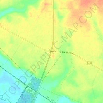
名称:Cooperville地形图、海拔、地势。
地点:Cooperville, Screven County, Georgia, United States (32.57073 -81.72400 32.61073 -81.68400)
平均海拔:47 米
最低海拔:22 米
最高海拔:67 米
其他地形图
点击地图以查看其地形、其海拔和其地势。
Sylvania
United States > Georgia > Screven County
According to the United States Census Bureau, the city has a total area of 3.8 square miles (9.8 km2), all land. Sylvania's elevation is 230 feet and is slightly higher than most of the land throughout Screven County.
平均海拔:60 米