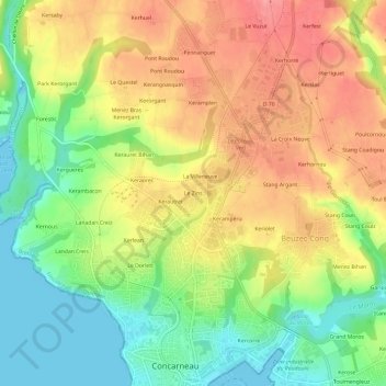
点击地图以显示海拔。
名称:Le Zins地形图、海拔、地势。
地点:Le Zins, Concarneau, Quimper, Finistère, Bretagne, France métropolitaine, 29900, France (47.87361 -3.93962 47.91361 -3.89962)
平均海拔:47 米
最低海拔:0 米
最高海拔:93 米
点击地图以查看其地形、其海拔和其地势。
France > Bretagne > Finistère > Concarneau > La Villeneuve
平均海拔:64 米
France > Bretagne > Finistère > Concarneau > Kercorre
平均海拔:13 米
France > Bretagne > Finistère > Concarneau > Keriolet
平均海拔:45 米