
Knatten地形图
点击地图以显示海拔。
关于这张地图
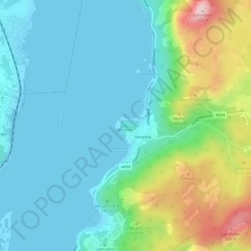
名称:Knatten地形图、海拔、地势。
地点:Knatten, Sandnes, Rogaland, 4329, Norway (58.88121 5.77060 58.88131 5.77070)
平均海拔:76 米
最低海拔:0 米
最高海拔:318 米
其他地形图
点击地图以查看其地形、其海拔和其地势。
Stavanger
The municipality of Stavanger is located in a coastal landscape, bordering the sea to the west and Boknafjorden in the northeast. The Byfjorden and Gandsfjorden run along the east side of the city. It is part of the Low-Jæren, a flat area of land consisting mostly of marsh, sand, and stone aur, that ranges…
平均海拔:42 米
Stavanger
The municipality of Stavanger is located in a coastal landscape, bordering the sea to the west and Boknafjorden in the northeast. The Byfjorden and Gandsfjorden run along the east side of the city. It is part of the Low-Jæren, a flat area of land consisting mostly of marsh, sand, and stone aur, that ranges…
平均海拔:37 米
Stavanger
The municipality of Stavanger is located in a coastal landscape, bordering the sea to the west and Boknafjorden in the northeast. The Byfjorden and Gandsfjorden run along the east side of the city. It is part of the Low-Jæren, a flat area of land consisting mostly of marsh, sand, and stone aur, that ranges…
平均海拔:42 米