
Pano Aqil地形图
点击地图以显示海拔。
关于这张地图
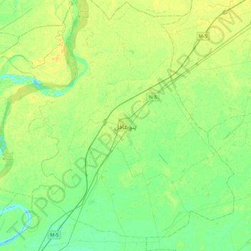
名称:Pano Aqil地形图、海拔、地势。
地点:Pano Aqil, Pano Akil Cantonment, Sindh, Pakistan (27.69582 68.95275 28.01582 69.27275)
平均海拔:66 米
最低海拔:57 米
最高海拔:76 米
其他地形图
点击地图以查看其地形、其海拔和其地势。
Karachi Division
Karachi lies very close to a major fault line, where the Indian tectonic plate meets the Arabian tectonic plate. However, Karachi lies near the western edge of the Indian Plate, on the Indo Gangetic Plain. Within the city of Karachi are two small ranges: the Khasa Hills and Mulri Hills, which lie in the…
平均海拔:89 米
Karachi Division
Karachi lies very close to a major fault line, where the Indian tectonic plate meets the Arabian tectonic plate. Within the city of Karachi are two small ranges: the Khasa Hills and Mulri Hills, which lie in the northwest and act as a barrier between North Nazimabad and Orangi. Karachi's hills are barren and…
平均海拔:89 米