
Calabanga地形图
点击地图以显示海拔。
Calabanga
The topographic landscape of the municipality could be characterized as generally flat with a slope 0-3%, gently sloping (3-8%) towards the direction of the eastern portion and finally rolling up to higher steeps towards the direction of the south-eastern part going to Mt. Isarog. The 0-3% slope is a broad area of flat to nearly level land which extends from Barangay Balongay along the Bicol River to Poblacion area and surrounding areas down to Barangay Manguiring. This is the dominant slope of the municipality.
关于这张地图
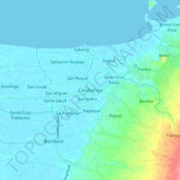
名称:Calabanga地形图、海拔、地势。
地点:Calabanga, Camarines Sur, Bicol Region, 4405, Philippines (13.66855 123.17576 13.74855 123.25576)
平均海拔:11 米
最低海拔:-1 米
最高海拔:79 米
其他地形图
点击地图以查看其地形、其海拔和其地势。
Nabua
Nabua has about 8,803.0600 hectares or 99.42% very low elevation or less than 100 meters elevation and remaining 51.3593 hectares or 0.58% of low elevation or between 100 and 300 meters elevation. Its slope covers about 7,927.3616 hectares or 89.53% which are level to nearly level (0-3%) while the remaining…
平均海拔:27 米
Mount Isarog
Philippines > Camarines Sur > Consocep
Mount Isarog is an active stratovolcano located in the province of Camarines Sur, Philippines, on the island of Luzon. The mountain has active fumaroles and hot springs. It has an elevation of 2,011.6 m (6,600 ft) above mean sea level.
平均海拔:671 米
Sipocot
Sipocot spans a total land area of approximately 218.60 square kilometers, making it one of the larger municipalities in Camarines Sur in terms of land size. Its topography is a mix of coastal plains, rolling hills, and forested uplands, with various rivers and streams contributing to the local ecosystem and…
平均海拔:106 米