
Trilby地形图
点击地图以显示海拔。
关于这张地图
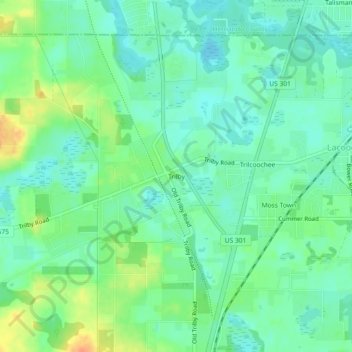
名称:Trilby地形图、海拔、地势。
地点:Trilby, Pasco County, Florida, 33593, United States (28.44244 -82.21361 28.48244 -82.17361)
平均海拔:27 米
最低海拔:13 米
最高海拔:53 米
其他地形图
点击地图以查看其地形、其海拔和其地势。
Zephyrhills
United States > Florida > Pasco County
Zephyrhills is characterized by its gently rolling topography, which contributes to its picturesque landscape. The area's elevation ranges between approximately 70 and 140 feet above sea level, giving it a distinct relief compared to the flat expanses typical of much of central Florida. This rolling terrain,…
平均海拔:32 米
New Port Richey
United States > Florida > Pasco County
New Port Richey présente un terrain essentiellement plat, caractéristique de la région. L'altitude de la ville oscille généralement autour de 30 pieds (environ 9 mètres) au-dessus du niveau de la mer, contribuant à sa vulnérabilité aux inondations lors de fortes pluies. La zone est parsemée de…
平均海拔:5 米
Dade City
United States > Florida > Pasco County
Dade City contains gently rolling topography with elevations from 60ft to 100ft.
平均海拔:33 米
Wesley Chapel
United States > Florida > Pasco County
According to the United States Census Bureau, the CDP has a total area of 6.1 square miles (16 km2), of which 6.1 square miles (16 km2) is land and 0.04 square miles (0.10 km2) (0.49%) is water. The elevation is about 100 feet (30 m), combined with an inland location, creates more temperature variation in the…
平均海拔:19 米
Dade City
United States > Florida > Pasco County
Dade City contains gently rolling topography with elevations from 60 ft to 100 ft.
平均海拔:33 米
Wesley Chapel
United States > Florida > Pasco County
According to the United States Census Bureau, the CDP has a total area of 6.1 square miles (16 km2), of which 6.1 square miles (16 km2) is land and 0.04 square miles (0.10 km2) (0.49%) is water. The elevation is about 100 feet (30 m), combined with an inland location, creates more temperature variation in the…
平均海拔:19 米
Saint Leo
United States > Florida > Pasco County
St. Leo contains rolling hills with elevations from 100 ft to 180 ft.
平均海拔:46 米
Saint Leo
United States > Florida > Pasco County
St. Leo contains rolling hills with elevations from 100 ft to 180 ft.
平均海拔:46 米
San Antonio
United States > Florida > Pasco County
San Antonio has a rolling topography with elevations varying from a low of 110 feet on the western edge of the city to as high as 183 feet on a hill overlooking Lake Jovita on the eastern edge of town.
平均海拔:44 米
San Antonio
United States > Florida > Pasco County
San Antonio has a rolling topography with elevations varying from a low of 110 feet on the western edge of the city to as high as 183 feet on a hill overlooking Lake Jovita on the eastern edge of town.
平均海拔:44 米
Dade City
United States > Florida > Pasco County
Dade City contains gently rolling topography with elevations from 60 ft to 100 ft.
平均海拔:33 米
Dade City
United States > Florida > Pasco County
Dade City contains gently rolling topography with elevations from 60ft to 100ft.
平均海拔:33 米
Zephyrhills
United States > Florida > Pasco County
Zephyrhills is known for its rolling topography, hence the name.
平均海拔:32 米