
Olga地形图
点击地图以显示海拔。
关于这张地图
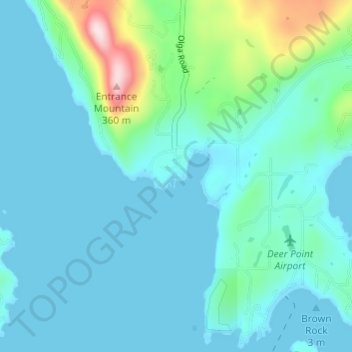
名称:Olga地形图、海拔、地势。
地点:Olga, San Juan County, Washington, 98279, United States (48.59955 -122.85546 48.63955 -122.81546)
平均海拔:55 米
最低海拔:-2 米
最高海拔:363 米
其他地形图
点击地图以查看其地形、其海拔和其地势。
Orcas Island
United States > Washington > San Juan County > Eastsound
Mount Constitution (elevation 2409 feet/734 meters) is the highest point in the San Juan islands. The mountain is part of Moran State Park, the largest public recreation area in the San Juan Islands, and the largest State Park in Washington. Moran State Park encompasses over 5,000 acres (2,000 ha) of woodland…
平均海拔:59 米
Orcas Island
United States > Washington > San Juan County > Eastsound
Mount Constitution (elevation 2,409 feet (734 meters) is the highest point in the San Juan islands. The mountain is part of Moran State Park, the largest public recreation area in the San Juan Islands, and the largest State Park in Washington. Moran State Park encompasses over 5,000 acres (2,000 hectares) of…
平均海拔:59 米