
Funny Rocks地形图
点击地图以显示海拔。
关于这张地图
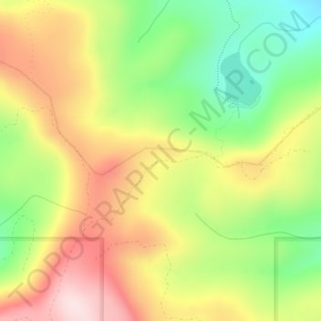
名称:Funny Rocks地形图、海拔、地势。
平均海拔:1,676 米
最低海拔:1,497 米
最高海拔:1,859 米
其他地形图
点击地图以查看其地形、其海拔和其地势。
Cle Elum
United States > Washington > Kittitas County
Cle Elum was originally inhabited by the Kittitas band of the Yakama tribe. The tribe fished salmon, steelhead, and trout from the Yakima River. The Salmon la Sac trails in the northern area of the region were created by the Kittitas people and were used as layovers for journeys into the higher altitudes of…
平均海拔:696 米
Snoqualmie Pass
United States > Washington > Kittitas County
Due to its elevation, Snoqualmie Pass experiences significantly lower temperatures than Seattle, and receives much more precipitation, much of it being snow. Snoqualmie Pass has a humid continental climate (Koppen: Dsb bordering Csb) with cold, very wet and snowy winters, and mild to warm, relatively dry…
平均海拔:955 米
Cle Elum
United States > Washington > Kittitas County
Cle Elum was originally inhabited by the Kittitas band of the Yakama tribe. The tribe fished salmon, steelhead, and trout from the Yakima River. The Salmon la Sac trails in the northern area of the region were created by the Kittitas people and were used as layovers for journeys into the higher altitudes of…
平均海拔:696 米
Cle Elum
United States > Washington > Kittitas County
Cle Elum has a humid continental climate, Köppen subtype Dsb. The elevation is 1909 feet and temperatures are cooler than areas to the east. The coldest month is December, a trait common in the Pacific Northwest. But hot temperatures still occur, and not just in summer: on March 18, 1968, the temperature…
平均海拔:696 米