
Seira地形图
点击地图以显示海拔。
关于这张地图
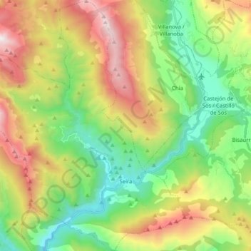
名称:Seira地形图、海拔、地势。
地点:Seira, Ribagorza, Huesca, Aragon, Spain (42.44484 0.31823 42.56125 0.47036)
平均海拔:1,421 米
最低海拔:733 米
最高海拔:2,535 米
其他地形图
点击地图以查看其地形、其海拔和其地势。
Sistema Ibérico
Spain > Aragon > Tarazona y el Moncayo > Tarazona
The geology of the Iberian System is complex, for it can hardly be defined as a homogeneous system. It is composed of a haphazard and motley series of mountain ranges, massifs, plateaus and depressions without a definite common petrologic composition and overall structure. Nummulite limestone, marble and…
平均海拔:1,906 米