
Carnac地形图
点击地图以显示海拔。
Carnac
Carnac est située sur la limite nord de Mor braz, sur la côte atlantique, entre le golfe du Morbihan à l’est et la presqu'île de Quiberon à l’ouest. C'est une commune littorale très vaste puisqu'elle occupe une surface de 3 271 hectares. L'altitude de la commune est faible, mais on rencontre de nombreuses buttes qui ont servi de repère pour la construction de monuments mégalithiques. Les communes limitrophes sont Ploemel, Crach, La Trinité-sur-Mer, Plouharnel et Erdeven.
关于这张地图
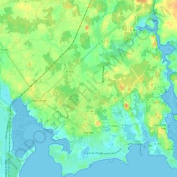
名称:Carnac地形图、海拔、地势。
平均海拔:12 米
最低海拔:-1 米
最高海拔:36 米
其他地形图
点击地图以查看其地形、其海拔和其地势。
Quily
France > Bretagne > Morbihan > Val d'Oust
Le finage de l'ancienne commune de Quily est constitué pour l'essentiel d'un plateau bosselé qui culmine à l'extrême ouest de son territoire à 135 mètres d'altitude et dont la pente décroit en direction de l'est jusque vers 70 mètres d'altitude. Ce plateau est limité par un escarpement d'une…
平均海拔:71 米
Île de Berder
France > Bretagne > Morbihan > Larmor-Baden
Longue d'environ 1 200 m du nord au sud et large de 300 m au maximum, l'île culmine dans sa partie centrale à 13 m d'altitude.
平均海拔:1 米