
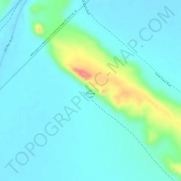
Mount Lucy地形图
点击地图以显示海拔。
关于这张地图
名称:Mount Lucy地形图、海拔、地势。
平均海拔:86 米
最低海拔:68 米
最高海拔:151 米
其他地形图
点击地图以查看其地形、其海拔和其地势。
Henley Brook
Henley Brook is situated on the flood plains of the Swan River, with regularly occurring seasonal floods. Two ephemeral streams from the river - Henley Brook and St. Leonard's Creek - traverse the suburb. Henley Brook is in the north-east near Brockman Street, while St Leonards Creek traverses the centre of…
平均海拔:28 米
Purnululu National Park
The Bungle Bungle Range, lying fully within the park, has elevations as high as 578 metres (1,896 ft) above sea level. It is famous for the sandstone domes, unusual and visually striking with their striping in alternating orange and grey bands. The banding of the domes is due to differences in clay content and…
平均海拔:277 米
Mount Melville
Australia > Western Australia > Albany
The mount has an elevation of 152 metres (499 ft).
平均海拔:36 米
Kalbarri
Kalbarri is a coastal town in the Mid West region located 592 km (368 mi) north of Perth, Western Australia. The town is located at the mouth of the Murchison River, which has an elevation of 6 metres (20 ft). It is connected by public transport to Perth via Transwa coach services N1 and N2.
平均海拔:57 米